Tag Archives: javascript

Webpack Upgrade Error: webpack.NamedModulesPlugin is not a constructor

Use [email protected] time: wrong type: webpack.namedmodulesplugin is not a constructor

Next, webpack.config.js:

const webpack = require('webpack');
const { merge } = require('webpack-merge');

const baseConfig = require('./webpack.config.base');

module.exports = merge(baseConfig, {
  mode: process.env.NODE_ENV,
  entry: {
    index: './app/index.ts',
  },
  plugins: [
    new webpack.NamedModulesPlugin(),
    new webpack.EnvironmentPlugin({
      NODE_ENV: 'development',
    }),
  ],
});

Cause of problem: in 5.0, namedmodules plugin has been removed

Refer to upgrading obsolete configuration items

NamedModulesPlugin → optimization.moduleIds: ‘named’

optimization: {
 moduleIds: 'named'
}

Modify configuration:

const webpack = require('webpack');
const { merge } = require('webpack-merge');

const baseConfig = require('./webpack.config.base');

module.exports = merge(baseConfig, {
  mode: process.env.NODE_ENV,
  entry: {
    index: './app/index.ts',
  },
  optimization: {
    moduleIds: 'named'
  },
  plugins: [
    new webpack.EnvironmentPlugin({
      NODE_ENV: 'development',
    }),
  ],
});

PS. moduleid it seems that the default value is named?Just remove namedmodules plugin.

Echarts Map Error: Error: Invalid geoJson format Cannot read property ‘length‘ of undefined

When displaying the districts and counties of Taizhou, Zhejiang Province, I found an error on the page. I found that the difference in the file is that there is a “type”: “geometrycollection”
Modify node in Yuhuan JSON_Modules\charts\lib\coord\geo\parsegeojason.js code

/*
 * Licensed to the Apache Software Foundation (ASF) under one
 * or more contributor license agreements.  See the NOTICE file
 * distributed with this work for additional information
 * regarding copyright ownership.  The ASF licenses this file
 * to you under the Apache License, Version 2.0 (the
 * "License"); you may not use this file except in compliance
 * with the License.  You may obtain a copy of the License at
 *
 *   http://www.apache.org/licenses/LICENSE-2.0
 *
 * Unless required by applicable law or agreed to in writing,
 * software distributed under the License is distributed on an
 * "AS IS" BASIS, WITHOUT WARRANTIES OR CONDITIONS OF ANY
 * KIND, either express or implied.  See the License for the
 * specific language governing permissions and limitations
 * under the License.
 */


/**
 * AUTO-GENERATED FILE. DO NOT MODIFY.
 */

/*
 * Licensed to the Apache Software Foundation (ASF) under one
 * or more contributor license agreements.  See the NOTICE file
 * distributed with this work for additional information
 * regarding copyright ownership.  The ASF licenses this file
 * to you under the Apache License, Version 2.0 (the
 * "License"); you may not use this file except in compliance
 * with the License.  You may obtain a copy of the License at
 *
 *   http://www.apache.org/licenses/LICENSE-2.0
 *
 * Unless required by applicable law or agreed to in writing,
 * software distributed under the License is distributed on an
 * "AS IS" BASIS, WITHOUT WARRANTIES OR CONDITIONS OF ANY
 * KIND, either express or implied.  See the License for the
 * specific language governing permissions and limitations
 * under the License.
 */

/**
 * Parse and decode geo json
 */
import * as zrUtil from 'zrender/lib/core/util';
import Region from './Region';

function decode(json) {
    if (!json.UTF8Encoding) {
        return json;
    }

    var jsonCompressed = json;
    var encodeScale = jsonCompressed.UTF8Scale;

    if (encodeScale == null) {
        encodeScale = 1024;
    }

    var features = jsonCompressed.features;

    for (var f = 0; f < features.length; f++) {
        var feature = features[f];
        var geometry = feature.geometry;

        if (geometry.type === 'Polygon') {
            var coordinates = geometry.coordinates;

            for (var c = 0; c < coordinates.length; c++) {
                coordinates[c] = decodePolygon(coordinates[c], geometry.encodeOffsets[c], encodeScale);
            }
        } else if (geometry.type === 'MultiPolygon') {
            var coordinates = geometry.coordinates;

            for (var c = 0; c < coordinates.length; c++) {
                var coordinate = coordinates[c];

                for (var c2 = 0; c2 < coordinate.length; c2++) {
                    coordinate[c2] = decodePolygon(coordinate[c2], geometry.encodeOffsets[c][c2], encodeScale);
                }
            }
        }
    } // Has been decoded


    jsonCompressed.UTF8Encoding = false;
    return jsonCompressed;
}

function decodePolygon(coordinate, encodeOffsets, encodeScale) {
    var result = [];
    var prevX = encodeOffsets[0];
    var prevY = encodeOffsets[1];

    for (var i = 0; i < coordinate.length; i += 2) {
        var x = coordinate.charCodeAt(i) - 64;
        var y = coordinate.charCodeAt(i + 1) - 64; // ZigZag decoding

        x = x >> 1 ^ -(x & 1);
        y = y >> 1 ^ -(y & 1); // Delta deocding

        x += prevX;
        y += prevY;
        prevX = x;
        prevY = y; // Dequantize

        result.push([x/encodeScale, y/encodeScale]);
    }

    return result;
}

export default function parseGeoJSON(geoJson, nameProperty) {
    decode(geoJson);
    return zrUtil.map(
        zrUtil.filter(geoJson.features, function (featureObj) {
            if (featureObj.geometry.geometries) {
                let geometry = featureObj.geometry.geometries.map(i => {
                    return i.coordinates;
                });
                let { type, properties} = featureObj;
                return {
                    type,
                    properties,
                    geometry
                };
            }
            // Output of mapshaper may have geometry null
            return (
                featureObj.geometry &&
                featureObj.properties &&
                featureObj.geometry.coordinates &&
                featureObj.geometry.coordinates.length > 0
            );
        }),
        function (featureObj) {
            var properties = featureObj.properties;
            var geo = featureObj.geometry;
            var coordinates = geo.coordinates;
            var geometries = [];

            if (geo.type === "GeometryCollection") {
                let geometry = {
                    type: "Polygon"
                };
                let coordinatesArr = featureObj.geometry.geometries.map(i => {
                    return i.coordinates;
                });
                geometry.coordinates = coordinatesArr;
                console.log(coordinatesArr, "coordinatesArr");
                coordinatesArr.forEach(i => {
                    geometries.push({
                        type: "polygon",
                        // According to the GeoJSON specification.
                        // First must be exterior, and the rest are all interior(holes).
                        exterior: i[0],
                        interiors: i.slice(1)
                    });
                });
            }
            if (geo.type === "Polygon") {
                console.log("coordinatesPolygon", coordinates);
                geometries.push({
                    type: "polygon",
                    // According to the GeoJSON specification.
                    // First must be exterior, and the rest are all interior(holes).
                    exterior: coordinates[0],
                    interiors: coordinates.slice(1)
                });
            }

            if (geo.type === "MultiPolygon") {
                zrUtil.each(coordinates, function (item) {
                    if (item[0]) {
                        geometries.push({
                            type: "polygon",
                            exterior: item[0],
                            interiors: item.slice(1)
                        });
                    }
                });
            }
            console.log(
                properties[nameProperty || "name"],
                geometries,
                properties.cp,
                "asdfasdfasdf"
            );
            var region = new Region(
                properties[nameProperty || "name"],
                geometries,
                properties.cp
            );
            region.properties = properties;
            return region;
        })
}

[Solved] VS Code Error: Vetur can‘t find ‘tsconfig.json‘ or ‘jsconfig.json‘

1. Cause

A new configuration file of vetur.config.js is added in vetur 0.31.0.
after this version, priority will be given to finding whether the project is equipped with tsconfig.json (TS project) or jsconfig.json (JS project).
if these two files are not found, go to vetur.config.js. If they are not found, this prompt will be thrown.

2. Explain

The JavaScript support of vscode can run in two different modes:
file range (without jsconfig.JSON)
in this mode, JavaScript files opened in vscode are regarded as independent units
as long as the file A.js does not explicitly reference the file b.ts (using// reference instructions or commonjs modules), there is no common project context between the two files.

3. Explicit project

(use jsconfig.JSON)

The JavaScript project is defined through the jsconfig.JSON file. The existence of such a file in the directory indicates that the directory is the root directory of the JavaScript project
the file itself can optionally list files belonging to the project, files to be excluded from the project, and compiler options (see below)
the JavaScript experience improves when you have a jsconfig.json file in your workspace that defines the project context
therefore, when you open a JavaScript file in a new workspace, we provide a prompt to create a jsconfig.json file.

4. Solution (1 out of 3)

4.1. Configure the vehicle plug-in and ignore the prompt </ H6>
 "vetur.ignoreProjectWarning": true,

4.2. Create jsconfig.json file in the project root directory </ H6>

Add code:

{
    "include": [
        "./src/*"
    ]
}
4.3. Create the vetur.config.js file in the project root directory </ H6>

Add code:

module.exports = {
    // vetur configuration, which will override the settings in vscode.  default: `{}`
    settings: {
        "vetur.useWorkspaceDependencies": true,
        "vetur.experimental.templateInterpolationService": true
    },
    // Normal projects use the default configuration default: `[{ root: './' }]`
}

Problems and solutions of error reporting in using swiper in Vue

In recent development, we encountered the problem of always reporting errors when using swiper components. Later, it was found that the problem was caused by the version

1. Download these two versions of plug-ins:
“wiper”: “^ 4.5.1”,
“Vue awesome wiper”: “^ 4.0.4”,

npm install [email protected] --save -dev
npm install swiper@4 --save -dev

2. Introduce in the component of xxxx.vue

<script>
import { swiper, swiperSlide } from "vue-awesome-swiper";
import "swiper/dist/css/swiper.css";
export default {
  name: "index",
  components: {
    swiper,
    swiperSlide
  }, 
};
</script>

3. Use in div

<swiper ref="mySwiper" v-bind:options="swiperOptions">
          <swiper-slide v-for="(item, index) in slideList" :key="index">
            <a v-bind:href="'/#/product'%20+%20'item.id'">
              <img v-bind:src="item.img" alt />
            </a>
</swiper-slide>

Error reported using layui $is not defined

The following error occurs when calling a function using the layui template

reason: Layu needs to be pre loaded and defined$

<script type="text/javascript" rel="script">
    layui.use(['table', 'layer', 'form','element'], function(){
        var table = layui.table;
        var layer = layui.layer;
        var form = layui.form;
        var element = layui.element;
        var $ = layui.$;

</script>

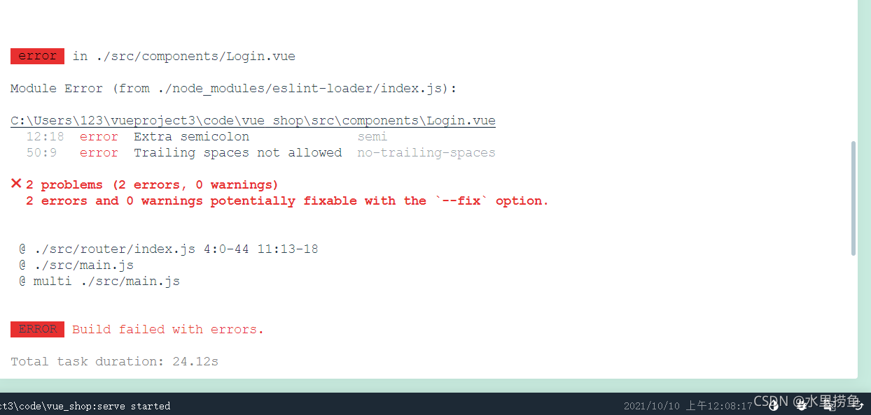
[Solved] ✖ 2 problem (1 error, 0 warnings) 2 error and 0 warnings potentially fixable with the`–fix`

Semi in eslint is to check whether the semicolon is wrong. No trailing spaces is the absence of spaces in the code Open. Eslintrc.js in the project and add the following code in the rules to solve the above problems. Just add the first and second lines of code in the box. Some are added to the problems later. It is recommended to add them because they are useful later.
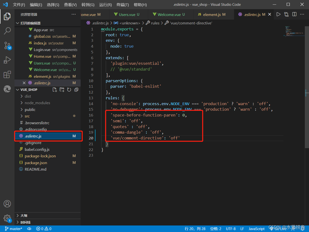
'space-before-function-paren': 0,
'semi': 'off',
'quotes' : 'off',
'comma-dangle' : 'off',
'vue/comment-directive': 'off'

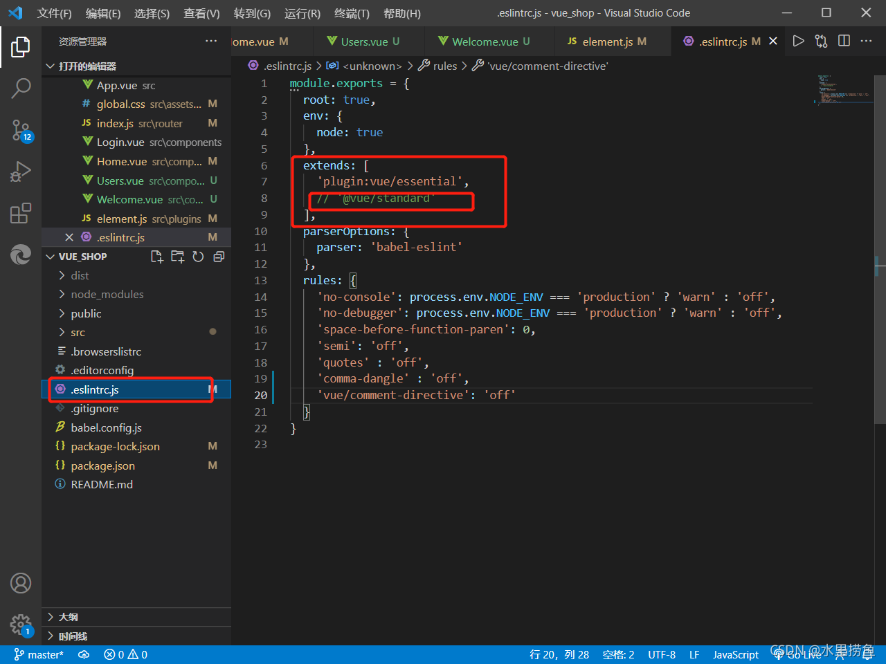
Eslint requires strict code format. Sometimes errors will occur when there are fewer or more spaces. It is recommended to replace the extensions in. Eslintrc.js in the project  ‘@ Vue/standard ‘is commented out. This will reduce many subsequent format problems.

IMG tag onerror event resolves infinite loop error reporting

Problem Description:

problem: the SRC picture in img tag failed to load, and a fragment icon will appear in the original picture position, which is very unpleasant. How to be more beautiful


Cause analysis:

because the reverse display resource cannot be found or the path does not exist, it will be processed according to the IMG default processing method


Solution:

1. Find a default picture to replace

2. Trigger with onerror event

3. The oneror event is triggered repeatedly

<img src="url" onerror= "this.οnerrοr='';this.src='static/images/nop.svg'">

Can be solved

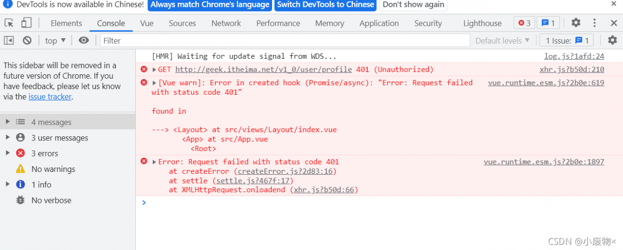
Error:Request failed with status code 401 [How to Solve]

Error: Request failed with status code 401

Error:

// Access to personal information
export const getUserInfoAPI = () => {
  return request({
    url: '/v1_0/user/profile',
    method: 'GET',
    Headers: {
      Authorization: `Bearer ${getToken()}`
    }
  })
}

Correct practice

// Access to personal information
export const getUserInfoAPI = () => {
  return request({
    url: '/v1_0/user/profile',
    method: 'GET',
    headers: {
      Authorization: `Bearer ${getToken()}`
    }
  })
}

In the process of writing request headers, the use of headers did not notice the case problem!!!